

Beyond the close call: Solving near miss detection with 3D digital lidar
Part 2 - Road safety series for National Pedestrian Safety month: Near miss detection
Welcome back to part two of Ouster’s blog series for October’s National Pedestrian Safety Month, led by the National Highway Traffic Safety Administration (NHTSA). In our first blog post, we explored outside of crosswalk pedestrian safety events. Part two will focus on an equally critical topic for pedestrian and vehicle safety: near miss detection.
The importance of detecting near miss incidents
Near miss incidents (also known as near misses) refer to situations where collisions almost occur but are narrowly avoided and can involve any road users (vehicles, pedestrians and cyclists). While near misses may not result in physical harm, they are crucial indicators of potential hazards on our roadways. Near misses highlight unsafe interactions that, if left unaddressed, could lead to serious accidents.
According to research based on Heinrich's Accident Triangle, for every 300 near misses, 29 minor injuries and one major injury or fatality occurred. Regardless of their significance, near misses are frequently overlooked in traffic safety discussions due to challenges in capturing and analyzing accurate data.
Despite investments in new technologies such as cameras, cities and Departments of Transportation (DoTs) continue to face considerable hurdles in monitoring near misses. Traditional traffic systems tend to concentrate on actual collisions, leaving a significant gap in our understanding of near miss activities. Additionally, the subjective nature of near misses means they often go unreported, further complicating data collection. Without comprehensive data, cities and transportation authorities struggle to identify high-risk areas, implement effective safety measures, and ultimately enhance safety for all road users.
How are near misses calculated?
Today, near misses are monitored using a combination of technologies, such as cameras, manual data collection methods, and analytical frameworks. This process often involves aggregating diverse data sources and significant manual effort to analyze and interpret the information effectively. Even then, the data can often be inaccurate due to challenges associated with certain technologies, like cameras, which is covered further below.Near misses are calculated using post-encroachment time (PET). PET is a measure of how close two road users come to each other. To calculate PET, you find the time difference between when the ‘leading’ vehicle arrives at a location and when the ‘following’ vehicle arrives at the same location. Functionally, this measurement represents (in seconds) how close two road users came to a collision.
To calculate PET, cities and DoTs are required to undergo the following steps:
Record the location of the leading vehicle at each time step until the vehicles are no longer on a collision course.
Calculate the PET for each location by finding the time difference between the leading vehicle and the following vehicle arriving at that location.
Select the minimum PET from the calculated PETs as the PET for the conflict line event.
PET is a critical indicator of conflict and can be used to calculate the severity of near misses in traffic intersections. Typical PET thresholds are:
PETs <4 seconds are considered as unsafe conflicts
PETs <2 seconds are considered as critical conflicts
Using these PET thresholds, the quantity and severity of near misses occuring at a given traffic intersection, can be captured.

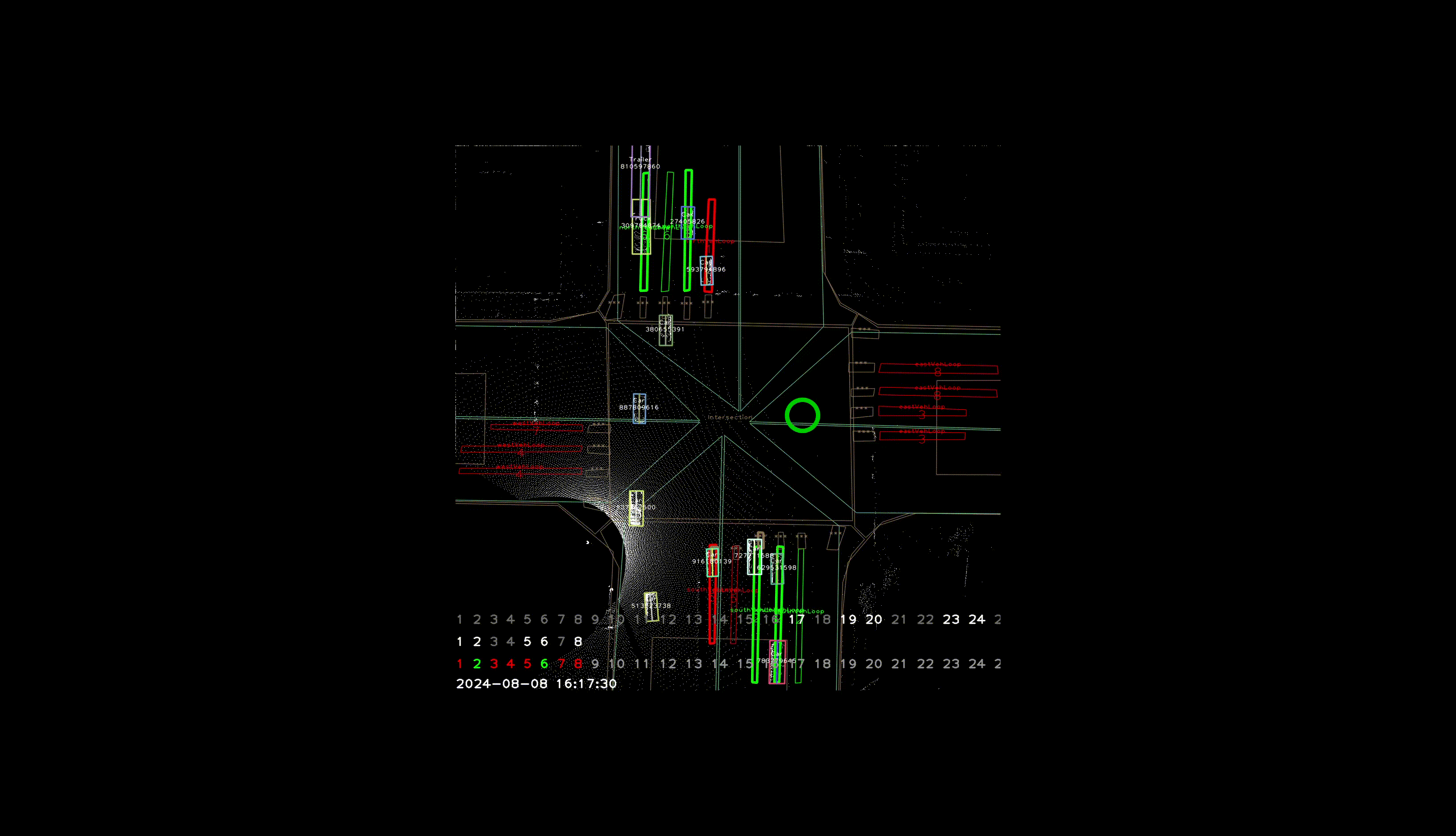
Visual representation of a near miss detection and PET estimation
Challenges calculating PET using cameras
Cities and DoTs have traditionally relied on cameras to help calculate PET by estimating a 2D bounding box for vehicles, which can then be used to calculate PET. Calculating PET with 2D cameras faces several challenges:
1. Limited depth of perception and field of view constraints: Cameras capture only 2D images, making it hard to accurately gauge distances and speed. Narrow coverage may require multiple cameras, complicating installation and maintenance. Additionally, cameras are not easily meshed together - where one camera may see an event and detect a near miss, a second camera viewing the same event from an alternate angle may not detect the near miss, therefore complicating data collection.
2. Environmental sensitivity: Lighting changes and weather conditions can hinder visibility and reduce data quality. Fast-moving objects may blur images, and obstructions can block views, leading to missed interactions.
3. Data processing limitations: High computational demands can delay real-time analysis, resulting in false positives and negatives. Distinguishing between different road users can also be difficult in busy environments and requires significant manual effort.
4. Privacy concerns: Cameras can capture personally identifiable information, raising privacy concerns within communities.
Overall, these limitations make cameras less reliable for accurately calculating PET.

The image captures the performance of Ouster digital lidar in poor light compared to a camera
Why Ouster digital lidar is advantageous for detecting near misses
Using Ouster digital lidar offers a significant advancement in addressing the limitations of conventional near miss detection systems:
High-resolution 3D mapping: Sensors continuously scan the environment and can produce up to 5.2 million points per second by processing light returns from each laser beam shot. Point clouds from the environment provide a 3D digital representation of an intersection or road to enable the accurate detection of road users.
Accurate near miss detection & tracking: Detecting all events is essential for capturing accurate near miss data. Ouster sensors can accurately detect and track small and large road users, which is crucial for recording all types of near miss incidents involving vehicles and pedestrians.
Privacy considerations: Sensors collect anonymized data, ensuring user privacy while still providing valuable safety insights.
High reliability in external conditions: Ouster sensors detect in poor light and adverse weather so high quality lidar data can be used by the Ouster BlueCity perception software for near miss detection.
Ouster BlueCity performing reliably during a heavy snow storm
How Ouster BlueCity works for near misses and PET calculations
As discussed earlier, traditional traffic management systems often lack the capability to capture near misses in real-time, and require multiple aggregated data sources to be accurate. This is where Ouster BlueCity benefits the most.
Ouster BlueCity combines high-resolution 3D digital lidars with advanced perception software to enable near misses to be detected and recorded. Data relating to the near miss incident is made available through the Ouster BlueCity cloud-based dashboard - all without any manual data collection efforts or the need to use other external aggregated data sources or technologies. This feature enhances road safety while saving significant time and resources.
How it works for near miss detection
Install: Following a fast and simple hardware and software install, Ouster BlueCity begins capturing multiple road user metrics (e.g. road user type, speed, distance, direction and count).
Recorded data: Near miss incidents are detected, recorded and stored for post-event analysis.
Data analytics: Near miss data is made available 24/7 in the Ouster BlueCity analytics platform.
Example near miss recording in Ouster BlueCity showcasing a critical near miss conflict of <1 second PET at an intersection
The 3D advantage in near miss detection
The visual below highlights the difference of Ouster BlueCity compared to traditional camera systems. Accurate detection of near-misses hinges on accurate identification of object boundaries, commonly referred to as bounding boxes. Many camera-based detection systems create 2D bounding boxes that may fail to align with actual object edges, as illustrated in the left image. This misalignment can lead to false positives, where the algorithm mistakenly identifies parts of the background as part of the object.
In contrast, as shown in the right image, a 3D lidar system generates bounding boxes that accurately align to the true contours of objects. This capability significantly reduces false positives, enhancing the reliability of the detection algorithm.

The left image represents potential areas of false positives from a 2D detection system. The image on the right showcases 3D detection with Ouster BlueCity
Near miss data analytics in the Ouster BlueCity dashboard
Two types of analytics are reported in the Ouster BlueCity dashboard: Conflicts and PET Rates.
Conflicts
Ouster BlueCity identifies near-miss conflicts by assessing the proximity of vehicles to pedestrians or other vehicles. An interactive heat map shows the location of all conflicts. Data is filtered for i) vehicles with vehicles (cars, bus, bikes, trucks) and ii) vehicles with non-vehicles (pedestrians) incidents. Additionally, users can filter data as follows:
Direction: The direction (turning movement) of the objects.
Leading vs following object: In the interactive heat map, users can distinguish when the leading object is a pedestrian or vehicle and the following object is a vehicle.
Speed: Speed range values (km/h and mph metrics).
PET seconds: PET in seconds from 0-10 seconds are filtered with dynamic sliders.
Video showcases the dynamic filter options for the conflicts heat map in the Ouster BlueCity dashboard
PET Rates
Ouster BlueCity calculates the PET Rate for near misses. This information is valuable for traffic engineers and urban planners, helping them to implement targeted interventions to improve safety. Users can view PET Rate data by dynamically filtering in the dashboard by:
- PET per 10,000 vehicles
- Near miss incidents classified by potential conflict time:
Critical (0-2 seconds)
Unsafe (2-5 seconds)
Safe (5-10 seconds)
Time
Video of PET Rate analytics available in the Ouster BlueCity dashboard. All data can be downloaded for full analysis
By using Ouster BlueCity on roads and intersections, cities and DoTs can effectively detect near misses, analyze the underlying causes and implement targeted safety interventions that may include changes in road design, signal timing and warnings. This proactive approach helps to enhance safety for all road users. To discover how Ouster BlueCity can enhance near miss detection and reduce accidents in your community, request a demo call today.
Hear from Vanderbilt University on near miss detection in Nashville, TN
The full webinar replay can be accessed here.

Dr William Barbour at Vanderbilt University discusses near miss detection in Nashville.
Related Articles

Nashville 100+ Intersection and Roadway Deployment
Ouster BlueCity to be deployed at 100+ additional intersections and roadways throughout NashvilleExpansion follows successful pilot in north Nashville area and multi-intersection deployment on Broadway for corridor-level analytics and traffic management intelligence
Built to last: Why Ouster BlueCity is a rugged and reliable choice for ITS deployments
Defining a New Era of Durability in ITS. Traditional ITS sensors fail in rain, glare, and snow. Ouster BlueCity uses proven digital lidar to maintain reliable performance at smart intersections 24/7.

Introducing the REV8 OS Family: The World’s First Native Color Lidar
A new generation of Ouster digital lidar, powered by custom L4 Ouster Silicon. Rev8 introduces native color lidar, provides up to double the range and resolution, and is designed for functional safety, reliability, affordability, and scale.