
The past decade has witnessed a concerning rise in pedestrian and cyclist fatalities in the U.S. According to preliminary data released by the Governors Highway Safety Association (GHSA), there were 7,318 projected pedestrian fatalities in the United States in 2023, down 5.4% from the previous year but 14.1% higher than 2019. The GHSA also reported that 1,149 cyclists were killed on U.S. roadways in 2023, a 4% increase from 2022. This trend contributes to real and perceived safety threats, as nearly 25% of U.S. adults reported that traffic is a barrier to safe walking. Of these, 79% selected vehicle speed as a contributing traffic characteristic.
Factors contributing to pedestrian and cyclist fatalities include:
Limitations of traditional detection methods: Legacy traffic sensors and cameras often struggle to detect, classify, and identify the accurate geolocation of vehicles and pedestrians, especially in low light or poor weather conditions, leading to inefficient signal timing and missed safety events.
Increased vulnerable road user (VRU) activity: With growing emphasis on sustainable transportation and active lifestyles, more pedestrians and cyclists share our roadways, increasing the need for dedicated VRU safety measures.
Complex urban environments: Intersections, in particular, present significant challenges due to the convergence of various traffic flows and potential conflicts, demanding more intelligent traffic management solutions.
Data silos: Valuable ITS data related to safety is often fragmented across different systems, hindering comprehensive analysis and proactive interventions for effective transportation planning.
Across the globe, transportation agencies, municipalities, traffic engineers, and research universities are responding to road safety challenges. They are united by a critical goal: the pursuit of Vision Zero – eliminating all traffic fatalities and severe injuries, and increasing safe mobility for all. Achieving this ambitious target requires a multi-faceted approach, leveraging data-driven insights and innovative technologies to understand and mitigate risks for all road users: pedestrians, cyclists, and motorists.
Since its adoption in 1997 by the Swedish Parliament, the Vision Zero framework has gained global traction and has been implemented in numerous countries worldwide. In the United States, the Vision Zero Network recognized 53 communities that met their established criteria for Vision Zero adoption as of August 2022. That number increased to nearly 70 as of February 2025. The development of Advanced Driver-Assistance Systems (ADAS) and Vehicle-to-Everything (V2X) communication has been greatly influenced by Vision Zero, as these technologies are key enablers of its ambitious goals to enhance road safety through the strategic use of technology.
The rise of ADAS to improve road user safety
The landscape of vehicles on our roads is rapidly evolving with the increasing integration of ADAS. Today's vehicles feature a growing array of driver assistance technologies with the core purpose of reducing fatalities and preventing injuries. These actions range from timely warnings of imminent collision risks to automatic emergency braking and lane-keeping assist systems to more sophisticated systems that pave the way for eventual autonomous driving. The European Union aims for a 50% reduction in road fatalities between 2019 and 2030, with the goal of achieving near-zero fatalities by 2050. To achieve these goals, wide-scale adoption of road safety technologies, including ADAS, is expected. The Partnership for Analytics and Research in Traffic Safety reports that ADAS penetration in new vehicles is already substantial, with 10 out of 14 key ADAS features exceeding 50% market penetration, and 5 surpassing 90%.
To fully realize the safety potential of ADAS-equipped vehicles, it is crucial to modernize road safety infrastructure. While ADAS technologies show promise in mitigating certain types of crashes, their effectiveness can be significantly enhanced by smarter infrastructure that provides richer, real-time data about vulnerable road users and dynamic environmental conditions. This necessitates evolution beyond basic traffic signals and static signage towards intelligent infrastructure capable of communicating directly with vehicles, pedestrians, and cyclists facing risks. The trend towards infrastructure communication is closely tied to V2X technology. The V2X market was valued at USD 3.59 billion in 2024 and is projected to reach USD 42.69 billion by 2031, which suggests that V2X may become a long-term fixture in infrastructure plans.
Introducing V2X: A new era of connected mobility and smart infrastructure
V2X communication technology is rapidly expanding and transforming road safety efforts, fueled by connected car advancements, a stronger focus on traffic safety, and supportive government and regulatory initiatives. At its core, V2X enables connected vehicles to communicate wirelessly with:
Other vehicles (V2V)
Infrastructure (V2I - also known as smart infrastructure)
Pedestrians (V2P)
The broader network (V2N)
This real-time exchange of information fosters cooperative perception and holds immense potential for improving situational awareness and preventing fatalities and injuries. Enhanced road safety relies heavily on assisted driving technology, and V2X communication facilitates the crucial real-time data exchange among vehicles and their surrounding environment.
Initially focused on V2V for collision avoidance, V2X has evolved to encompass infrastructure-based intelligence. Roadside Units (RSUs) can now broadcast critical information like signal phase and timing (SPAT). At the same time, connected vehicles equipped with Onboard Units (OBUs) can receive and utilize this data for enhanced decision-making and ADAS.
In a significant move for transportation technology, the Federal Communications Commission (FCC) adopted final rules on cellular-vehicle-to-everything (C-V2X) in a unanimous, bipartisan Second Report and Order on November 21, 2024. This FCC action paves the way for C-V2X to revolutionize communication between vehicles, roadside infrastructure, and other road users, providing safer and more efficient mobility. By enabling this direct communication, C-V2X aims to reduce crashes, improve traffic flow, support autonomous vehicle development, and drive the modernization of road infrastructure. The clarity these regulations provide is expected to drive innovation and economic growth, fueling the adoption of connected and intelligent transportation technologies. Among these advanced technologies, three-dimensional (3D) digital lidar-powered solutions stand out as a leading contender.
Ouster BlueCity: Intelligent infrastructure for a connected future
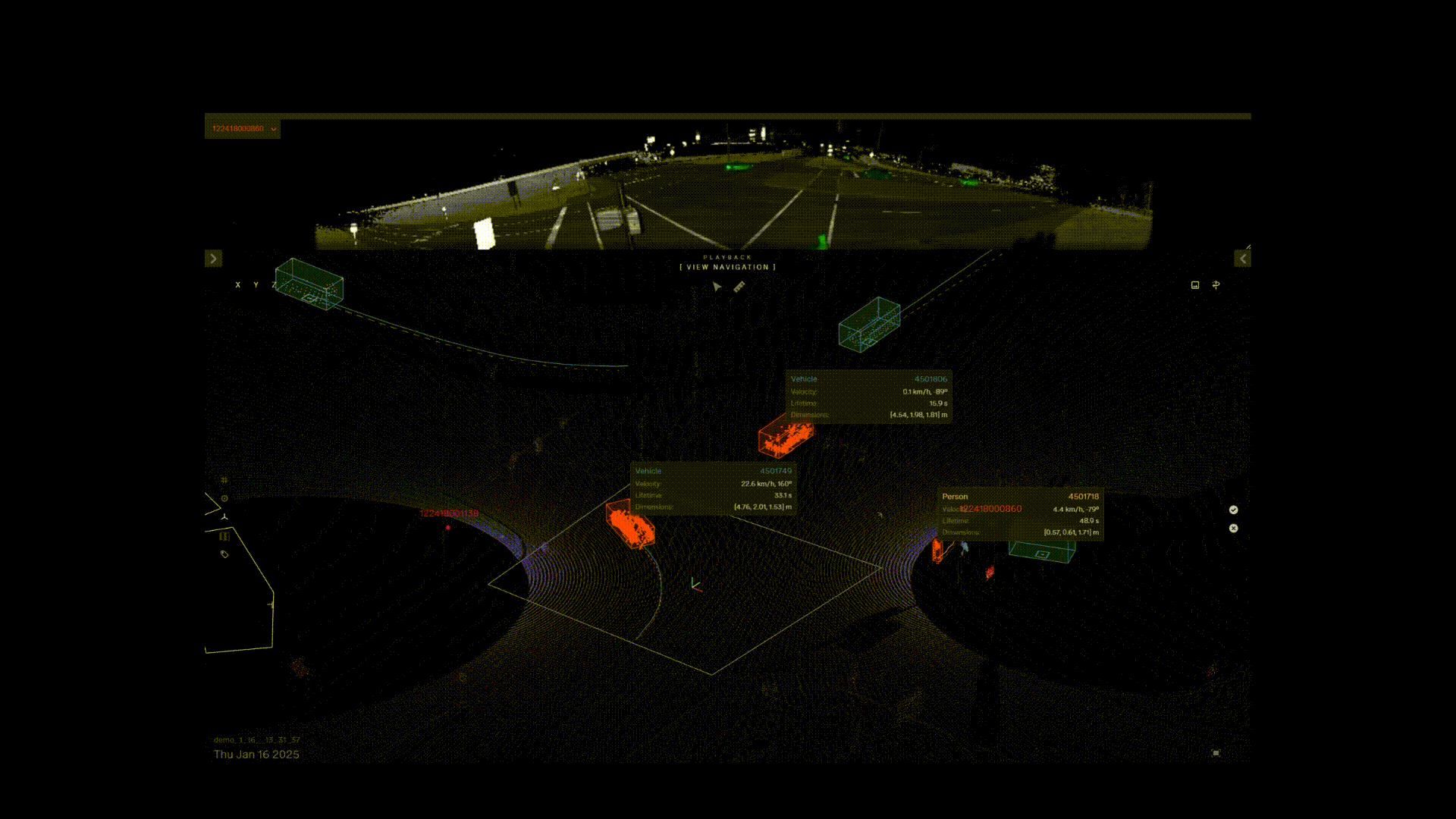
Ouster is at the forefront of road infrastructure modernization, V2X, and intelligent transportation transformation. Ouster BlueCity is a turnkey solution that combines Ouster’s 3D digital lidar with its deep learning AI perception software and data analytics. It enables the creation of a real-time 3D digital traffic twin of an intersection or road to reliably detect, classify, and track multimodal road users—in all weather and lighting—for a modernized traffic and road safety solution.
Example Ouster BlueCity recording of an intersection detecting and classifying pedestrians, different types of vehicles and cyclists.
The Ouster BlueCity lidar system provides a complete traffic actuation and road safety solution. The system automates data collection in the cloud to monitor road events more accurately for vehicles, pedestrians, and cyclists, providing high-quality data analytics that enable quick safety interventions and long-term planning optimizations.
This out-of-the-box system provides a truly complete and cost-efficient traffic management solution that gives traffic operators and city planners high-quality insights about their intersections and public corridors. What’s more, it can be seamlessly integrated for V2X communications to better prepare for the increased adoption of ADAS-equipped vehicles and their safety potential.
How Ouster BlueCity powers V2X for enhanced safety
Building on the many advantages of V2X discussed above, Ouster BlueCity's creation of a real-time 3D digital traffic twin offers significant advantages over traditional traffic detection sensors. Three-dimensional spatial awareness enables accurate detection, classification, and tracking with the exact geolocation of all road users with near real-time precision. This accuracy is crucial to the proactive identification of potential safety threats to vulnerable road users, enabling the generation of dependable safety messages for V2X applications.
Here's how Ouster BlueCity works for a V2X integration:
Detection and tracking for accurate safety messages: Following a fast and simple install of Ouster BlueCity at an intersection or road, transportation agencies and municipalities can accurately detect and track the precise geolocation, speed, and trajectory of different types of vehicles, pedestrians, and cyclists.
Standardized safety message generation: Using accurate data from Ouster BlueCity, the system converts object metadata into standardized SAE J2735 Basic Safety Messages (BSM) for vehicles and Personal Safety Messages (PSM) over 5G for pedestrians and cyclists. Furthermore, Ouster BlueCity supports the more advanced SAE J3224 (SDSM), enabling the combination of information for all road users into a single, more comprehensive message that provides richer contextual awareness to connected vehicles.
Broadcasting safety information to connected road users: A RSU receives the safety messages from Ouster BlueCity and broadcasts them to connected vehicles and VRUs equipped with OBUs This allows drivers and other road users to receive real-time alerts about potential hazards, such as a pedestrian entering a crosswalk outside of the designated time or a cyclist approaching rapidly, even if they are not directly visible to the driver, significantly enhancing VRU safety.
Seamless integration with RSUs: Ouster BlueCity boasts technology-agnostic full V2X integration capabilities designed for plug-and-play integration with various RSU vendors. Adhering strictly to SAE standards requires no custom API development, which simplifies deployment and ensures interoperability.
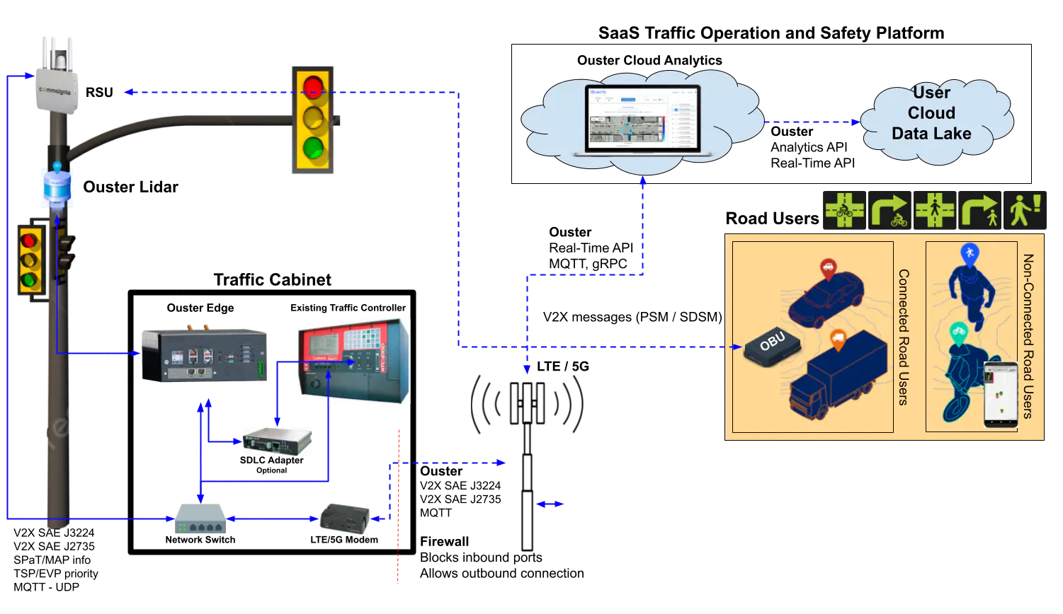
Technical installation diagram of Ouster BlueCity and V2X
Key Benefits of Ouster BlueCity for V2X road safety:
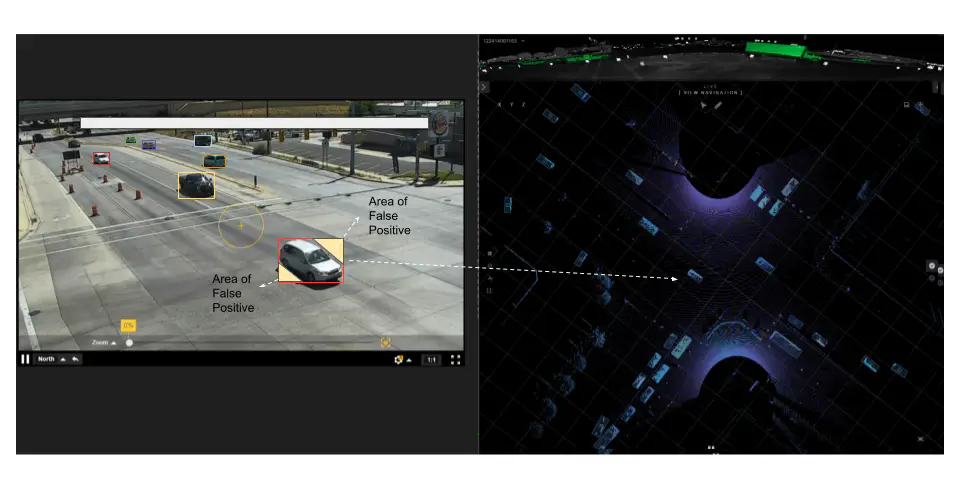
High-resolution 3D data for accurate near detection and tracking: Unlike cameras which provide 2D views,, Ouster BlueCity generates precise 3D bounding boxes, or object boundaries. This is crucial for safety-critical applications and provides precise details on road user type and accurate geolocation with low latency.
The visual below highlights the difference between Ouster BlueCity’s 3D view and the 2D views of traditional camera systems. Accurate detection of safety events hinges on accurate identification of object boundaries, commonly referred to as bounding boxes. Many camera-based detection systems create 2D bounding boxes that may fail to align with actual object edges, as illustrated in the left image. This misalignment can lead to false positives, where the algorithm mistakenly identifies parts of the background as part of the object.
In contrast, as shown in the right image, a 3D lidar system generates bounding boxes that accurately align to the true contours of objects. This capability significantly reduces false positives, enhancing the reliability of the detection algorithm.
In summary, 3D spatial awareness significantly contributes to accurate detection and a substantial reduction in false positives, ensuring the reliability of V2X detection and communication.
Reliability in external conditions: Ouster's digital lidar sensors provide enhanced detection in poor lighting and adverse weather conditions like rain, snow, and fog compared to cameras and other sensor types. This ensures high-quality data is consistently provided for reliable V2X communication.
Supports advanced messaging protocols: Ouster BlueCity ensures flexibility and the ability to leverage more advanced messaging protocols for comprehensive safety information sharing including BSM/PSM (J2735) and SDSM (J3224). The Ouster BlueCity system is designed for scalability to meet the demands of growing connected infrastructure.
Privacy-conscious data collection: Ouster digital lidars collect anonymized data, which respects user privacy as no personally identifiable information is captured.
Non-invasive install and low maintenance: Installation is non-invasive, low cost, and, in the majority of deployments, it does not require road closures or ongoing maintenance.
A system that instills confidence: Ouster’s high-resolution OS lidar sensors are NDAA (Section 848) compliant, and Buy America(n) and IP68 and IP69K certified. In addition, Ouster BlueCity is system-level NEMA TS2 certified.
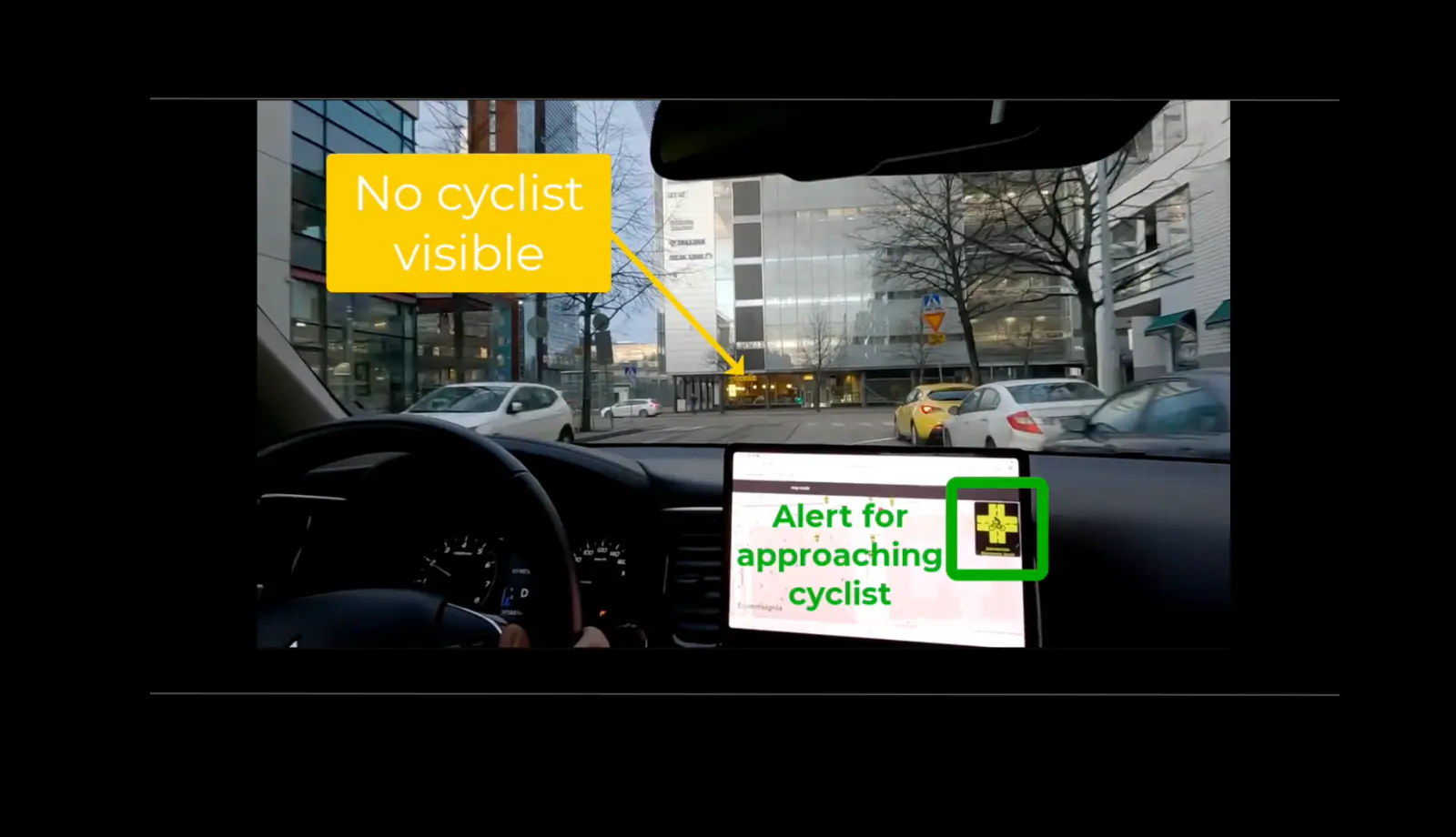
An example demonstration of Ouster BlueCity detecting a cyclist and sending an advance alert directly via the OBU to the driver.
Ouster BlueCity with V2X in action
Ouster BlueCity has been successfully tested and deployed in various programs, including collaborations with the University of Michigan at the MCity testbed, showcasing its accuracy as validated by independent research, and ongoing deployments with transportation agencies such as Utah DoT and Chattanooga DoT.
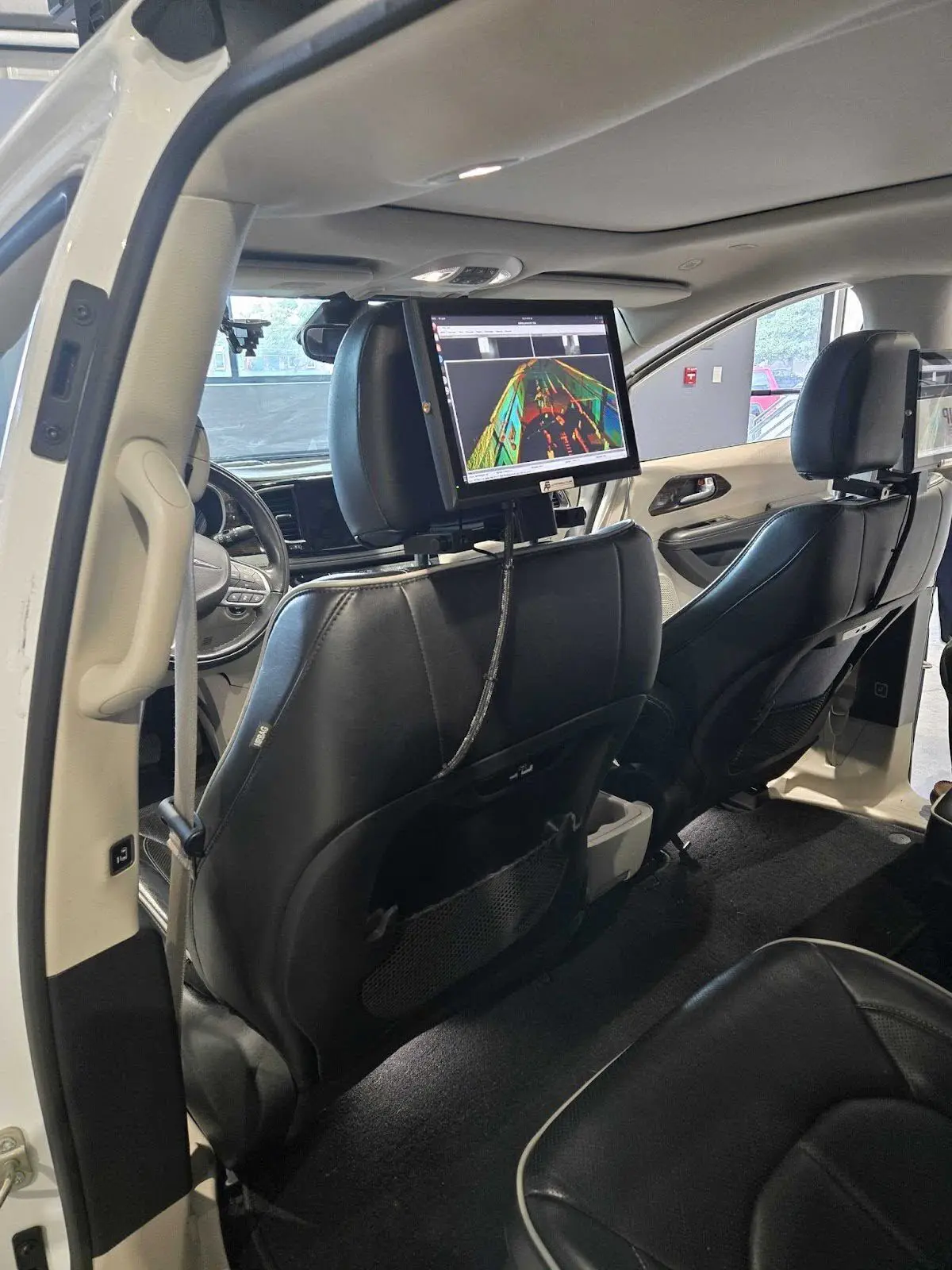
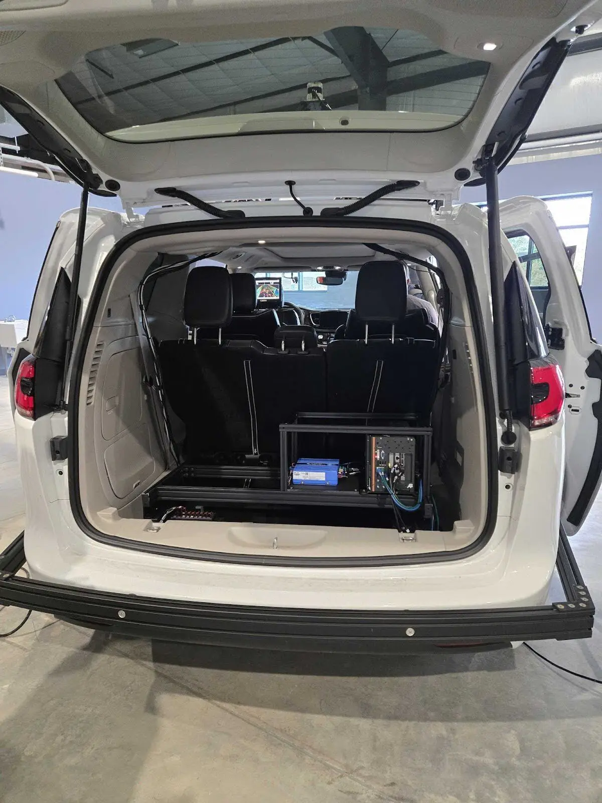
The below images showcase Ouster BlueCity integrated with an RSU and OBU in a vehicle, which was used by the University of Chattanooga, Tennessee, to successfully test and demonstrate a V2X integration with Ouster BlueCity. The City of Chattanooga is deploying Ouster BlueCity in over 120+ intersections across the city. The Commsignia RSU used in this example demonstration has achieved OmniAir Certification for C-V2X Roadside Unit.
Driving towards Vision Zero with smart integrated solutions
Ouster BlueCity represents a significant step towards achieving Vision Zero by providing an integrated solution that addresses key trends in pedestrian, cyclist and vehicle safety. By leveraging the power of 3D lidar and intelligent AI perception, transportation agencies and municipalities can go beyond V2X communications to also:
Improve intelligent signal actuation: Optimize traffic flow based on the real-time presence and type of all road users, leading to reduced congestion and improved safety.
Enhance safety analytics: Gain deeper data-driven insights into near-miss events, jaywalking patterns, red-light running, and other safety-critical behaviors through a comprehensive analytics dashboard.
Proactive intervention: Utilize real-time alerts and data-driven insights to implement targeted safety measures and infrastructure improvements.
Move towards connected and autonomous vehicle readiness: Build the smart infrastructure necessary to support the future of connected and autonomous vehicles.
Learn more about Ouster BlueCity actuation and safety analytics in these recent Ouster blogs:
Ready to modernize your intersections and roadways?
Ouster BlueCity is helping to enable the industry shift from static to smart road infrastructure. With a 3D lidar-powered solution that delivers accurate detection, classification, and tracking, combined with robust safety analytics, transportation agencies and municipalities can modernize road infrastructure in a cost-effective all-in-one solution. This approach effectively prepares infrastructure for the requirements of ADAS and facilitates seamless V2X communication, paving the way for safer, more efficient, and truly connected transportation systems.
Contact us today to learn how our Ouster BlueCity can benefit your community and contribute to safer intersections and corridors.
Related Articles
From inductive loops to lidar: How lidar-powered traffic systems are redesigning urban traffic management and safety
Tackle wrong-way driving head on with 3D digital lidar technology
Includes additional insights on stopped vehicle and pedestrian detection

Part 3 Road safety series for National Pedestrian Safety month: Red light runners
Part 3 - Ouster’s blog series for National Pedestrian Safety Month