
Tackle wrong-way driving head on with 3D digital lidar technology
Includes additional insights on stopped vehicle and pedestrian detection
Wrong-way driving (also known as WWD) occurs when a driver operates a vehicle against the intended flow of traffic, creating a highly dangerous situation. Research from the Iowa State University Institute for Transportation revealed that this issue can arise on various types of roads, including highways, freeways, and arterial roads, particularly at off-ramps. Although many serious wrong-way driving incidents occur on highways, it is not uncommon for collisions to also occur on urban intersections and one-way streets. Regardless of the specific circumstances, when a driver mistakenly heads into oncoming traffic, the risk of head-on collisions significantly increases and the driver endangers both themselves and other road users.
Fortunately, wrong-way incidents are relatively rare, although the impact of these collisions is often magnified by their circumstances and the high speeds involved. Many wrong-way driving incidents result in fatalities or serious injuries. According to the Federal Highway Administration (FHWA), approximately 500 people died in wrong-way crashes annually in 2019 and 2020 in the United States. The AAA Foundation for Traffic Safety revealed that between 2010 and 2018, wrong-way drivers made up 52.8% of fatalities from accidents, followed by passengers (5.7%) and occupants of other vehicles (41.1%). Data from other countries is relatively limited although research from the National Highways reported that wrong-way driving incidents on England’s motorways rose to almost 900 in the year leading up to June 2023, which was an increase of 102 incidents from the previous year.
1. The retirement of legacy detection in favor of AI-Powered traffic management
For decades, many critical traffic systems have relied on technologies like inductive loops, cameras and radar. While these tools offer basic traffic counting and presence detection, they are limited by data scarcity, vulnerability to environmental factors, and detection constraints. For example, inductive loops only detect a vehicle’s presence at a single point, offering limited insight into the complex, multimodal reality of today’s streets.
In 2026, I expect to see accelerated municipal programs dedicated to replacing this aging infrastructure. The mandate is clear: deploy solutions capable of generating rich, automated data. This systemic replacement is not merely a technology upgrade; it is a prerequisite for deploying effective AI models and achieving modern operational standards.
For years, agencies have tested individual technologies—including lidar sensors—at one or two intersections within a municipality. In 2026, I expect to see these small-scale lidar pilots evolve into formalized, city-wide deployments. Progressive transportation leaders are now ready to commit to proven, scalable solutions. This transition requires robust procurement specifications, established data governance protocols, and confidence in a system's ability to seamlessly integrate with existing municipal infrastructure and budgets—moving technology from "pre-spec" testing environments into reliable, integrated systems.
Ouster is already seeing this transition in action; this year alone, we announced two of the largest lidar-enabled rollouts in the industry, covering 130+ intersections in Chattanooga and over 100 in Utah,. These projects demonstrate that this technology is no longer just a "pilot"—it is ready for major infrastructure and safety programs.

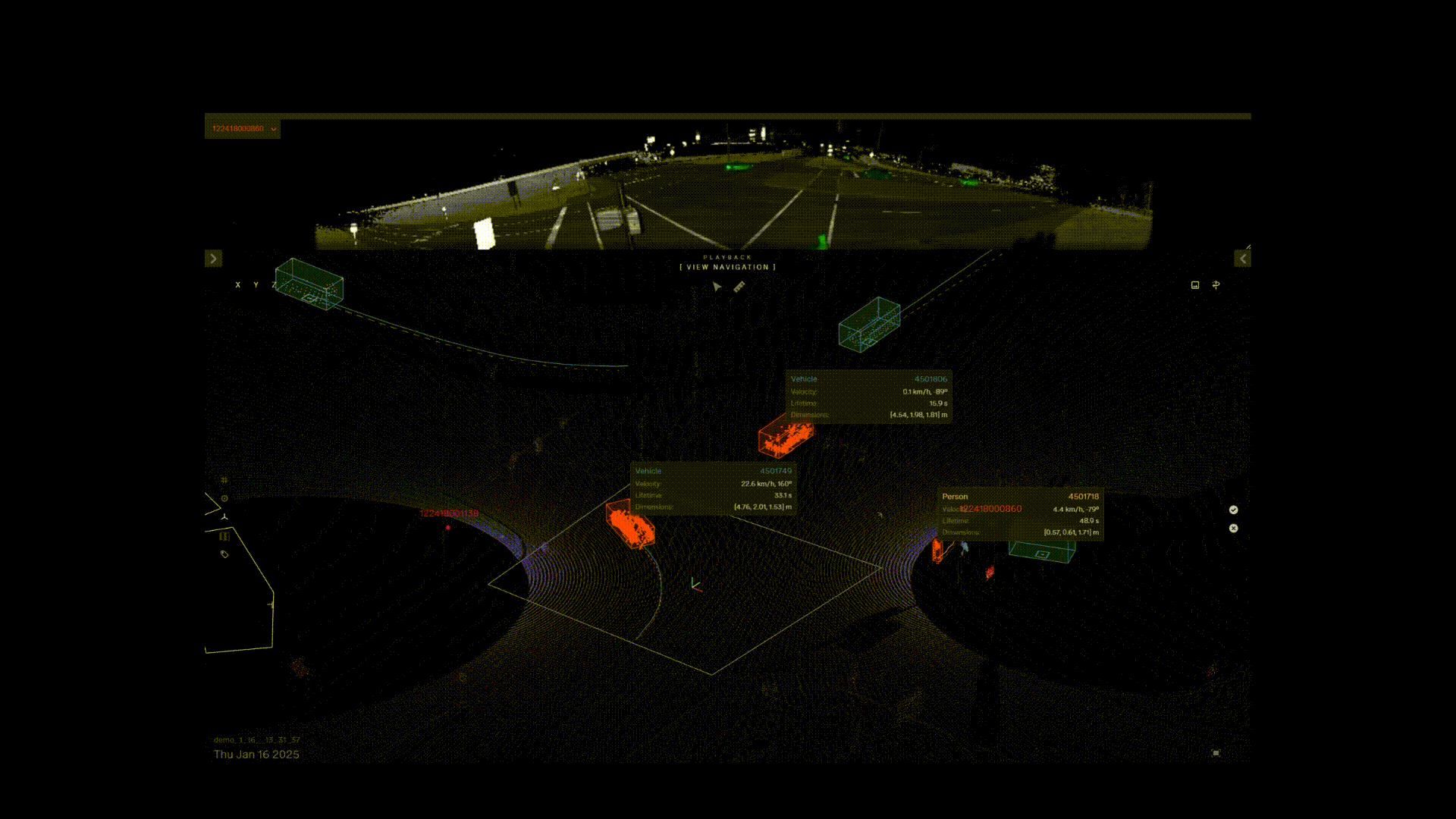
The Ouster BlueCity wrong-way detection deployment can also detect, classify and track stopped vehicles and pedestrians for improved highway and road safety.
What are the main causes of wrong-way driving?
Wrong-way driving incidents can arise from a variety of factors, with the National Transportation Safety Board (NTSB) noting that almost half of wrong-way accidents are caused by drunk drivers. Alcohol and some prescription medications can severely impair a driver’s judgment, coordination, and cognitive abilities, heightening the risk of critical errors such as wrong-way driving incidents. Moreover, age plays a role in incidents, as does an over-reliance on GPS technology, which can mislead drivers in complex traffic situations. The design of roadways, especially divided highways and arterial roads, can further exacerbate confusion, making them particularly prone to wrong-way driving events
Detecting and understanding the causes and consequences of wrong-way driving is essential for departments of transportation (DoTs) and highway administrations to develop effective mitigation strategies. Key interventions to prevent wrong-way driving or lessen the severity of related incidents include:
Modifying road design with improved signage and markings.
Installing wrong-way driving detection systems.
Strengthening enforcement efforts.

The Ouster BlueCity wrong-way detection deployment can also detect, classify and track stopped vehicles and pedestrians for improved highway and road safety.
Why lidar for wrong-way driving detection?
Compared to other technologies like radar and thermal imaging, digital lidar offers distinct advantages for detecting vehicles involved in wrong-way driving:
High resolution and range: Digital lidar delivers exceptional high-resolution 3D spatial awareness. By generating detailed 3D point clouds, lidar sensors can capture position, speed and direction of vehicles at long ranges and in near real-time. This capability is advantageous for the early detection of wrong-way drivers, as it allows for timely alerts that can help prevent wrong-way driving crashes.
Vehicle color and surface agnostic: Lidar is not affected by vehicle color or reflectivity and can effectively detect dark vehicles because it emits its own laser light, allowing it to illuminate the environment regardless of ambient light conditions. Lidar measures distance based on the time it takes for laser pulses to return, allowing it to detect vehicles regardless of their color or surface characteristics.
High reliability in all lighting conditions: The Special Investigation Report by the National Transportation Safety Board stated that 78 percent of wrong-way collisions occurred between 6:00 p.m. and 6:00 a.m. It is crucial that a wrong-way detection system can handle the most challenging lighting conditions from glaring sun to darkness. Digital lidar sensors work effectively in low light because they use laser beams to actively illuminate the environment. By measuring the time it takes for laser pulses to reflect off objects and return to the sensor, lidar accurately calculates distances regardless of light levels. Lidar's sensitivity to reflections enables the detection of vehicles at considerable ranges, while its resilience against sun glare and shadows helps ensure reliable performance in other lighting conditions.
Adverse temperatures and weather: Lidar’s ability to generate precise 3D point clouds allows for accurate object detection even in low-visibility situations such as snow, fog or rain. While water droplets can scatter radar waves, lidar's laser beams more effectively penetrate these conditions. Lidar is also less affected by heat distortion, which can interfere with a thermal camera's ability to detect objects in high temperature or humid environments.
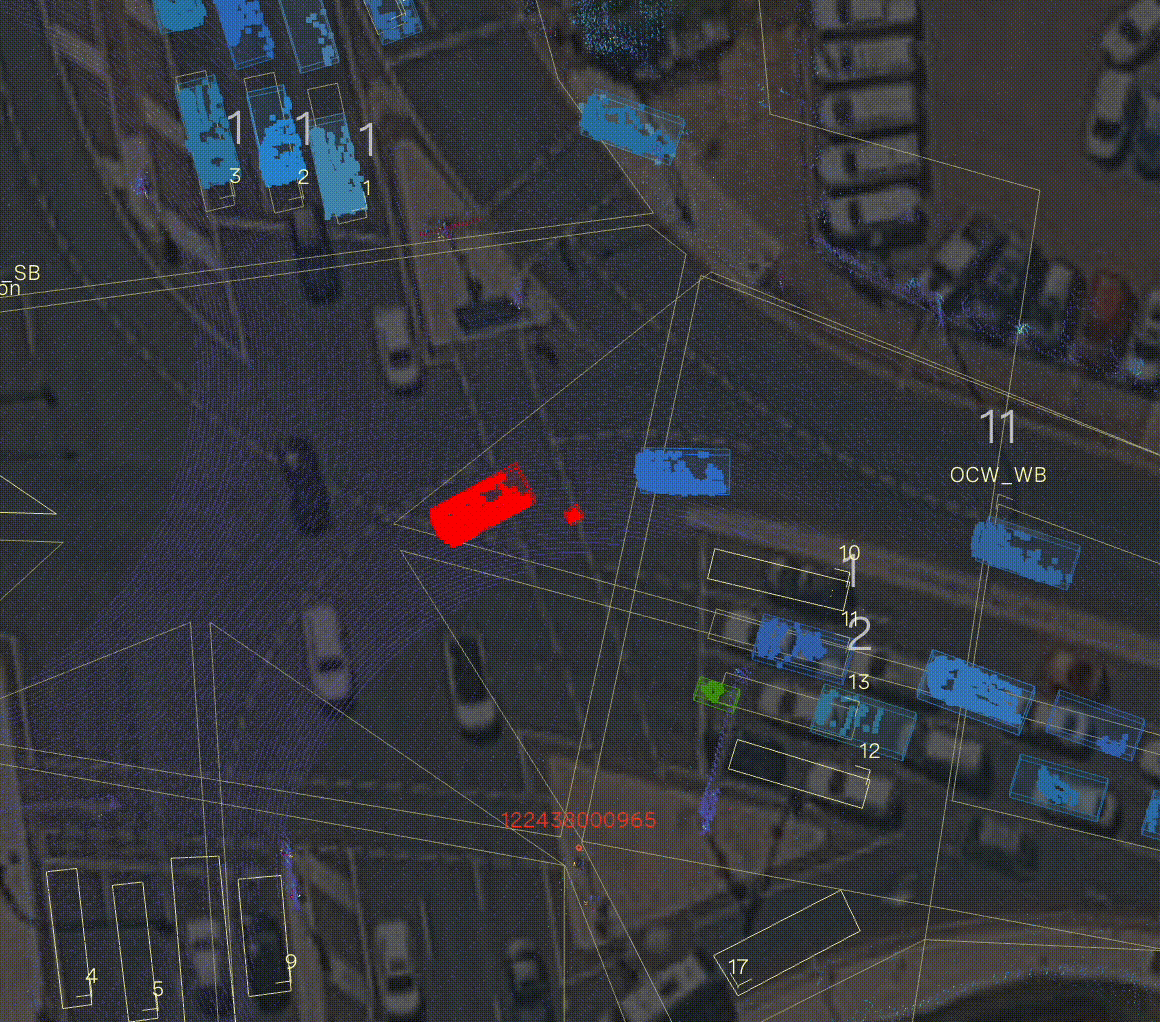
Example automated near miss recording in Ouster BlueCity
What are the challenges with wrong-way driving detection systems?
Commonly used wrong-way detection systems face several significant challenges for accurate detection, environmental adaptability, system integration, and data analytics:
Radar and thermal imaging detection challenges: Radar's lower resolution and limited ability to capture fine details creates challenges as a wrong-way driving solution, especially when distinguishing between closely spaced vehicles on roads. Additionally, as radar’s emitted signals are material-dependent, it is difficult to separate objects with similar reflection characteristics. In contrast, thermal cameras can struggle to detect dark vehicles as their surfaces absorb more heat, resulting in minimal temperature contrast with the environment. Variations in material emissivity also play a role, as darker surfaces may emit less infrared radiation, further diminishing their thermal signature.
Environmental limitations: ITS that rely on cameras can struggle in poor lighting, adverse weather, and obstructed fields of view, affecting detection accuracy and leading to high rates of false positives and negatives. As many wrong-way driving collisions happen at night (see following section), it is crucial for detection systems to perform effectively in all lighting conditions.
Integration and cost issues: Incorporating detection systems into existing infrastructure can be complex and costly, with ongoing maintenance required to ensure system reliability. This maintenance burden can become significant over time.
Data analytics challenges: Limited data insights regarding wrong-way driving events hinder DoTs and administrations from fully understanding the extent of the problem and developing effective mitigation strategies. Not all incidents are detected or accurately recorded, complicating the analysis of wrong-way driving issues.

Looking ahead with lidar-powered ITS
The path ahead for ITS is defined by intelligence, verifiable data, and tangible results for the public. By embracing these technologies, we empower agencies to manage traffic more efficiently to proactively protect our most vulnerable citizens, and ensure our digital infrastructure is robustly ready for the connected vehicle era.
The rapid evolution of 3D spatial intelligence marks a turning point for transportation agencies worldwide. As the global lidar market is projected to reach over $12 billion by 2030, I believe we are moving into an era where high-resolution, long-range sensing is no longer a luxury, but the new standard for resilient urban design. By providing a "digital twin" of the roadway that remains accurate despite challenging weather and lighting conditions, digital lidar empowers agencies to move beyond fragmented, reactive fixes; instead, it offers a unified path toward Vision Zero by delivering the granular data necessary to protect vulnerable road users and the real-time responsiveness required to eliminate congestion through intelligent, adaptive signal control and improve road safety through next-generation analytics and alerts.
Looking toward the remainder of the decade, the integration of digital lidar with V2X communication will redefine the "Smart City" from a concept into a connected reality. Transportation leaders now have the tools to build a proactive infrastructure that not only sees the world in 3D but communicates those insights directly to vehicles and pedestrians to help prevent accidents before they occur. By investing in this high-fidelity data foundation today, agencies are doing more than just upgrading sensors; they are helping communities and businesses reclaim lost economic value and are ensuring that our future transportation networks are as safe, efficient, and equitable as the communities they serve.

Related Articles
Built to last: Why Ouster BlueCity is a rugged and reliable choice for ITS deployments
Defining a New Era of Durability in ITS
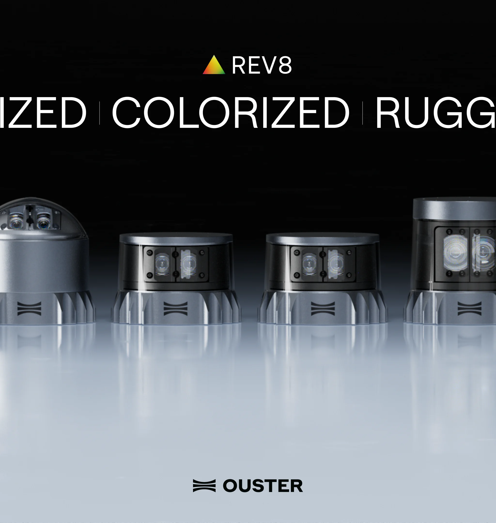
Introducing the REV8 OS Family: The World’s First Native Color Lidar
A new generation of Ouster digital lidar, powered by custom L4 Ouster Silicon. Rev8 introduces native color lidar, provides up to double the range and resolution, and is designed for functional safety, reliability, affordability, and scale.

Evolution of Ouster BlueCity
From Canadian roots to global leadership, Ouster BlueCity is modernizing the intelligent transportation sector. Learn how BlueCity started, grew at Velodyne and further at Ouster into what it is today.