
The City of Chattanooga in Tennessee, known for its beautiful scenery and technological innovation, is one of the first cities in the United States to deploy lidar as part of its Vision Zero safety initiatives. In a partnership among the Chattanooga Department of Transportation (CDOT), University of Tennessee-Chattanooga’s Center for Urban Informatics and Progress (CUIP), and other private and public partners, Ouster lidar is being used across the busy downtown area. Ouster lidar provides the city and researchers with real-time pedestrian and vehicle data used for near-miss analysis and for identifying safety measures.
We announced this groundbreaking deployment earlier this year. Today, we will be diving into why Chattanooga selected Ouster lidar, how they’re using the lidar data, and their plans to make lidar a critical part of the city’s future infrastructure.
If you are interested in partnering with us on a smart city or traffic project, you can learn more about our lidar solution for ITS or reach out to our team!
Pedestrian safety is a growing priority for Chattanooga
Pedestrians in Chattanooga are 23x more likely to be fatally injured compared to other road users, and 6x more likely to suffer an injury in the event of an accident. As an urban metropolitan with increasing pedestrian, bicyclist, and scooter traffic, the city of Chattanooga knew it was time to take action and work towards Vision Zero goals.
This marked the establishment of the MLK Smart Corridor, a testbed jointly established by the Chattanooga Department of Transportation (CDOT), the University of Tennessee-Chattanooga’s Center for Urban Informatics and Progress (CUIP), and other public and private partners. The MLK Smart Corridor is a 1.25-mile living laboratory that runs through downtown Chattanooga and is home to smart city technologies (including Ouster lidar) and V2X applications. With real-time data collected from real-world events, CDOT and CUIP researchers are able to implement new technologies and safety measures that can be later scaled to other parts of the city and state of Tennessee.
The challenge with cameras: detection accuracy and precision
CDOT and CUIP first needed data to understand current vehicle and pedestrian movement patterns and to evaluate the performance of the city’s infrastructure. This data would then be used to analyze near-miss incidents and inform safety measures, two critical components of achieving Vision Zero.
At the time of the project start, the MLK Smart Corridor was already outfitted with several cameras per intersection. With the processed camera footage, CUIP researchers used 2D-based computer vision and object tracking to retroactively estimate distances between vehicles and pedestrians and to calculate time-to-collision. However, cameras’ lack of depth awareness and inability to provide accurate positioning of objects often led to calculation errors.
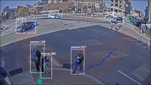
Researchers previously guesstimated object position and speed from 2D camera footage, leading to data and calculation inaccuracies. Video footage courtesy of CUIP.
Researchers previously guesstimated object position and speed from 2D camera footage, leading to data and calculation inaccuracies. Video footage courtesy of CUIP.
External light conditions also negatively impacted the detection accuracy of cameras. Because cameras rely on ambient light for detection, their performance deteriorates with shadow, glare, and low-light. The majority of traffic accidents occur after dark, so CDOT and CUIP needed alternative sensing solutions that could reliably provide data throughout all hours of the day.
Using Ouster lidar data to develop near-miss and time-to-collision algorithms
Data accuracy is absolutely critical when it comes to near-miss analysis: even a few centimeters or one second off could be too late. Knowing that they needed a better solution, CUIP researchers turned to the most advanced detection technology for traffic detection – lidar. Lidar provides extremely accurate, 3D representations of entire environments, including detection of vehicles, pedestrians, and bicyclists through varying lighting and weather conditions. Distance between objects at cm-level accuracy can be easily extracted, solving for the miscalculation problems CUIP researchers were experiencing with 2D-based computer vision.
In tandem with situational and weather data collected from other sources, researchers could predict accidents and pinpoint hot zones based on road users involved, time of day, and other external factors.
For this project, two Ouster lidar sensors are installed at each intersection, providing full coverage of the intersection, the curbs, and sidewalks. Ouster lidar data is processed on the edge by Seoul Robotics’ perception software that outputs object detection, classification, tracking, velocity, counts, and even trajectory information. This additional data can be used in future phases of the project for connected vehicle applications, automated traffic signal performance, and emergency vehicle preemption.
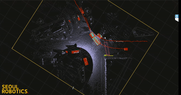
Snippet of processed Ouster lidar data at one of the downtown intersections. Video courtesy of CUIP.
Snippet of processed Ouster lidar data at one of the downtown intersections. Video courtesy of CUIP.
Technology that puts privacy at the forefront
Citizen privacy was an equally important consideration for CDOT and CUIP when selecting partners and technologies. CUIP follows a set of guidelines about how they use the collected data and seeks to collaborate with partners who adhere to the same regulations. In line with these privacy standards, lidar never reveals any facial or personally identifiable information. Ouster also offers a unique “Privacy-Safe Mode” with all our sensors, which turns off the ambient imagery output and processes only the point cloud information. This extra layer of protection gives cities additional assurance that citizen privacy is always protected.

Digital lidar protects privacy
CUIP takes this a step further to protect citizen privacy. All lidar data collected at the intersections is processed on the edge and only anonymized metadata, such as object detection and classification, is stored.
With the prevalence of AI and advanced detection technologies, we anticipate tightened regulations around privacy and facial recognition technologies. Major cities, including San Francisco and Portland, have already banned the use of facial recognition by the government. Chattanooga has shown the importance of being transparent and intentional about the way they collect and use data. We anticipate other cities will follow suit, and are proud to be at the forefront of this movement with our lidar technology.
Expanding lidar deployment across the city of Chattanooga

Ouster sensors being installed at an intersection on the MLK Smart Corridor in Chattanooga
Today, Ouster lidar sensors are running at two intersections within the MLK Smart Corridor: MLK Jr. Blvd and Market St., and MLK Jr. Blvd and Georgia Ave. These locations were selected for their close proximity to city parks and event spaces and their subsequent high volume of pedestrian activity.
CDOT and CUIP plan to expand lidar deployments along the MLK Smart Corridor and to other locations across Chattanooga, creating a connected ecosystem that can support connected vehicles and advanced V2X applications. This continued collaboration between CDOT, CUIP, Ouster, and other industry partners is critical as the city works towards achieving Vision Zero.
Stay tuned for more updates on this project.
To learn more about what Ouster is doing in the smart cities and infrastructure space, check out these resources:
- Ouster for ITS webinar (featuring our friends from Chattanooga!)
- Overview of Ouster’s lidar solution for ITS
- Reach out to our team.