

Unlocking new smart traffic capabilities for your city with lidar
There is a technological revolution happening on our roadways today. Parallel to the Industry 4.0 trends in manufacturing and logistics, Intelligent Transportation Systems (ITS) are improving the ways road users travel around the world. Cities and municipalities that aren’t deploying advanced technologies for smart traffic are falling behind and are leaving their citizens at risk in an increasingly fast-paced and crowded world.
ITS America is the premiere tradeshow to learn about new advancements in transportation technology nationwide. As the show has evolved over the years, lidar has become a staple technology in the transportation solution stack. Experts with decades of experience as traffic engineers, DOT officials, or technology integrators understand that lidar brings distinct advantages over cameras, radar, or loops when it comes to traffic control and analytics. This year in Dallas, Ouster demonstrated powerful new software solutions built upon our high-resolution digital lidar to improve the safety and efficiency of our roadways.

Ouster at ITS America 2023
Why lidar in ITS?
Lidar offers the perfect combination of perception performance, data robustness, and system simplicity for traffic solutions. All three of these categories are essential to operate a safe and efficient intersection, corridor, parking lot, or crosswalk.
- Perception performance is critical to be able to perform actuation of traffic control signals and output accurate (and useful) analytics for signal performance measures (SPMs). Detecting the presence of an object is the minimum requirement here, but lidar offers far more than that. With our high-resolution digital lidar, our detection system not only detects the pedestrian, vehicle, or bicyclist but also classifies the object accurately and continuously tracks it throughout the monitored space. Lidar also provides deterministic distance data, meaning that the exact location of every object is measured rather than calculated. Camera technology can detect and classify objects in ideal weather conditions (something we’ll touch on next), but cameras require inference to determine the estimated location (and therefore speed) in space of objects, leading to inconsistencies that output inaccurate SPM insights. Radar technology provides deterministic distance data in all weather conditions, but it does not have high enough resolution to detect slow and/or smaller objects such as pedestrians and provide accurate classification – a critical parameter in ITS applications focused on the safety of vulnerable road users.
- Data robustness in any weather or lighting condition is key to this industry since systems are always operating outdoors. Cities cannot risk safety just because it is raining or snowing on any particular day. And with 75% of pedestrian fatalities occurring in low-light conditions, camera technologies simply cannot move the needle of safety in our cities. Ouster lidar penetrates environmental obscurants to maintain high detection performance in all weather conditions. And compared to cameras that can be blinded by sun glare or headlights, lidar operates outside the visible spectrum and therefore is unaffected by harsh lighting or complete darkness.

Lidar perception outperforms camera and radar in dark lighting conditions

Lidar detects objects through obscurants like fog or dust
- System simplicity is a critical factor that influences the effort of installation, quality of user experience, and overall cost. Here is a visual comparison of the four main types of traffic monitoring sensors:


- Installation: With Ouster lidar, one single sensor can cover an entire typical intersection. Compared to the typical configuration of 4-6 cameras and/or 8 radars, the simplicity of the lidar installation is obvious. Our sensor can be mounted at a standard ~15ft (~4.5m) with a basic arm and bracket. Altogether, our lidar system is simply easier to install than other systems, saving costs while deploying safety technologies faster.

Ouster BlueCity offers complete intersection coverage with one sensor
- User experience: traffic monitoring systems can be difficult to extract valuable insights from. Our dashboard UI makes it easy to visually analyze traffic flow, identify and playback conflicts such as near-misses or red light runners, and export data to key stakeholders such as city planners.
- Overall cost: fewer sensors, easier installation, and rare maintenance. Ouster’s smart traffic solution is often less expensive upfront and over the lifetime of the system compared to other sensor technologies.
Flexible ITS solutions
Ouster offers a unique package of ITS software capabilities. At ITS America, we had deep discussions with all types of customers looking for technologies that match their timeline and level of expertise. Whether you are a traffic engineer needing something up and running quickly or a system integrator looking to build a custom, differentiated solution for your end customer, we have the perfect solution to meet your needs.
Turn the key and go with BlueCity
With BlueCity, we provide cities and integrators with a turnkey solution for traffic actuation and analytics. Right out of the box, BlueCity can be installed within a couple of hours and immediately collect accurate multimodal data to be used for real-time signal actuation and aggregated analytical insights. We have already deployed hundreds of systems around the world for smart intersections, corridors, crosswalks, curb management, and even for connected vehicles and V2X.
At the show, visitors were impressed by BlueCity’s analytical capabilities. Within the cloud dashboard, users can intuitively monitor SPMs and conflicts and with the click of a button, can playback lidar recordings of every event triggered based on user-defined parameters. That means every near-miss, red-light-runner, and jaywalker is recorded and can be analyzed down to the centimeter.
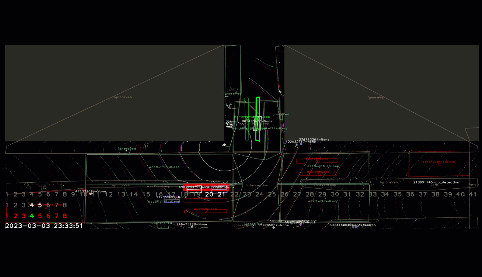
BlueCity near miss detection and playback
We also showed off a live demo of BlueCity traffic actuation using an Oriux PEEK traffic controller. By drawing virtual loops, the user can configure the system in minutes and immediately begin improving the efficiency of their roadways. On top of that, multimodal detection means loops can be triggered by bicyclists and pedestrians, not just vehicles as is the case with inductive loops. And BlueCity is compatible with NTCIP and SDLC protocols, making the integration process even more seamless.
Build custom solutions with Gemini
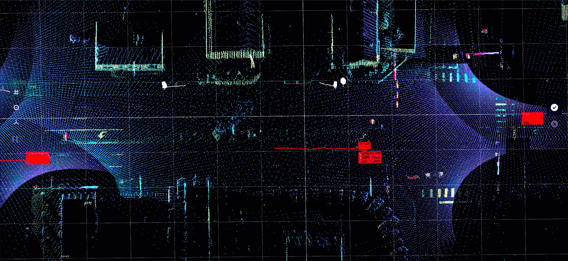
Underneath BlueCity is Gemini, Ouster’s digital lidar perception platform. Gemini is perfect for an ITS technology integrator who wants to build its own custom solution to meet the specific needs of its customers. At the show, we demonstrated real-time pedestrian tracking around our booth to show the power of Gemini’s tailored perception performance based on high-resolution digital lidar. Many customers in the ITS space are already deploying Gemini at the edge to deliver the baseline object list and zone occupancy list on which to build traffic control and analytic dashboards. Gemini gives the power to the integrator to determine what is the most optimal system design for any given ITS deployment.
BlueCity near miss detection and playback
Corridor monitoring with Ouster Gemini
Ouster is the ITS one-stop-shop
After showing off our solutions to hundreds of visitors from cities, DoTs, and technology integrators, there is clear excitement about what this technology can do for the industry. With BlueCity and Gemini, deploying traffic technologies to improve safety and efficiency is easier, more affordable, and more data-rich than ever before.
If you would like to see these solutions in action, please reach out to our team to set up a demo of either BlueCity or Gemini. Our experts are happy to walk you through what it could look like to implement Ouster ITS solutions according to your needs.