

Forest Biodiversity Powered by Three Dimensional Deep Learning and the Ouster OS0
Deep Forestry has built a push-button autonomous survey drone, powered by Ouster lidar, for dense cluttered environments such as industrial buildings, warehouses, or underground tunnels.

Deep Forestry has built a push-button autonomous survey drone, powered by Ouster lidar, for dense cluttered environments such as industrial buildings, warehouses, or underground tunnels. Their foremost surveying task is forest or agricultural inventory management, carbon credit monitoring, and biodiversity protection. These surveying tasks require more than data capture alone – they need to also analyze and compute what is being mapped by the drone. Armed with this information, forestry and agricultural management services are able to make informed decisions in line with their business goals as well as their sustainability and climate goals.
Headquartered in Northern Europe – Deep Forestry built one of the world’s first three dimensional deep learning biodiversity classification algorithms. The algorithm can learn new types of species classification for a fraction of the cost compared to existing AI systems, opening up a whole new world of forest, agricultural, and biodiversity classification.
With Deep Forestry’s approach, governments, forest owners, and farmers, including in the developing world, are now able to accurately assess their ecosystems, enabling them to maximize the utility and sustainability of their land. Factors such as plantation yield, carbon flux, biodiversity, regulatory adherence, insect or disease proliferance, cultural heritage, and profitability, can now be acquired by untrained workers without any drone piloting expertise.
“What Ouster and Deep Forestry are doing together, combined with these massive industries like forestry, tree based agriculture, snack foods, etc. can have a hugely positive impact on global forest ecosystems, society, and the climate as a whole.” – Levi Farrand, Deep Forestry CEO
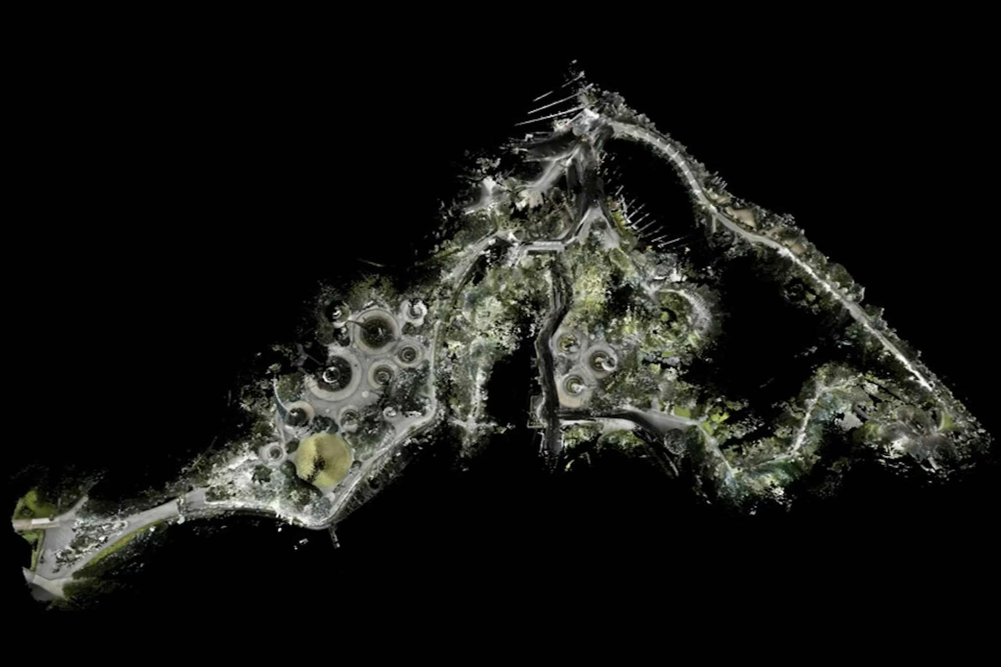
Deep Forestry’s system is impressively autonomous. Quite literally operating at the touch of a button, flying into a densely forested area, self-piloting in-between the trees without user input. Typically covering an area of 800+ trees in 10-20 minutes, the drone based scanning system is capable of creating a highly accurate digital twin with every individual tree (or object) identified and precisely measured, including previously unavailable metrics such as wood quality class, and terrain driveability. An equivalent manual system does not exist. Previous measurements were collected with a combination of rough manual estimates and eye-sight extrapolation. This means that current management practices are not much better than guesswork with significant errors and inaccuracies costing millions throughout various downstream value chains.

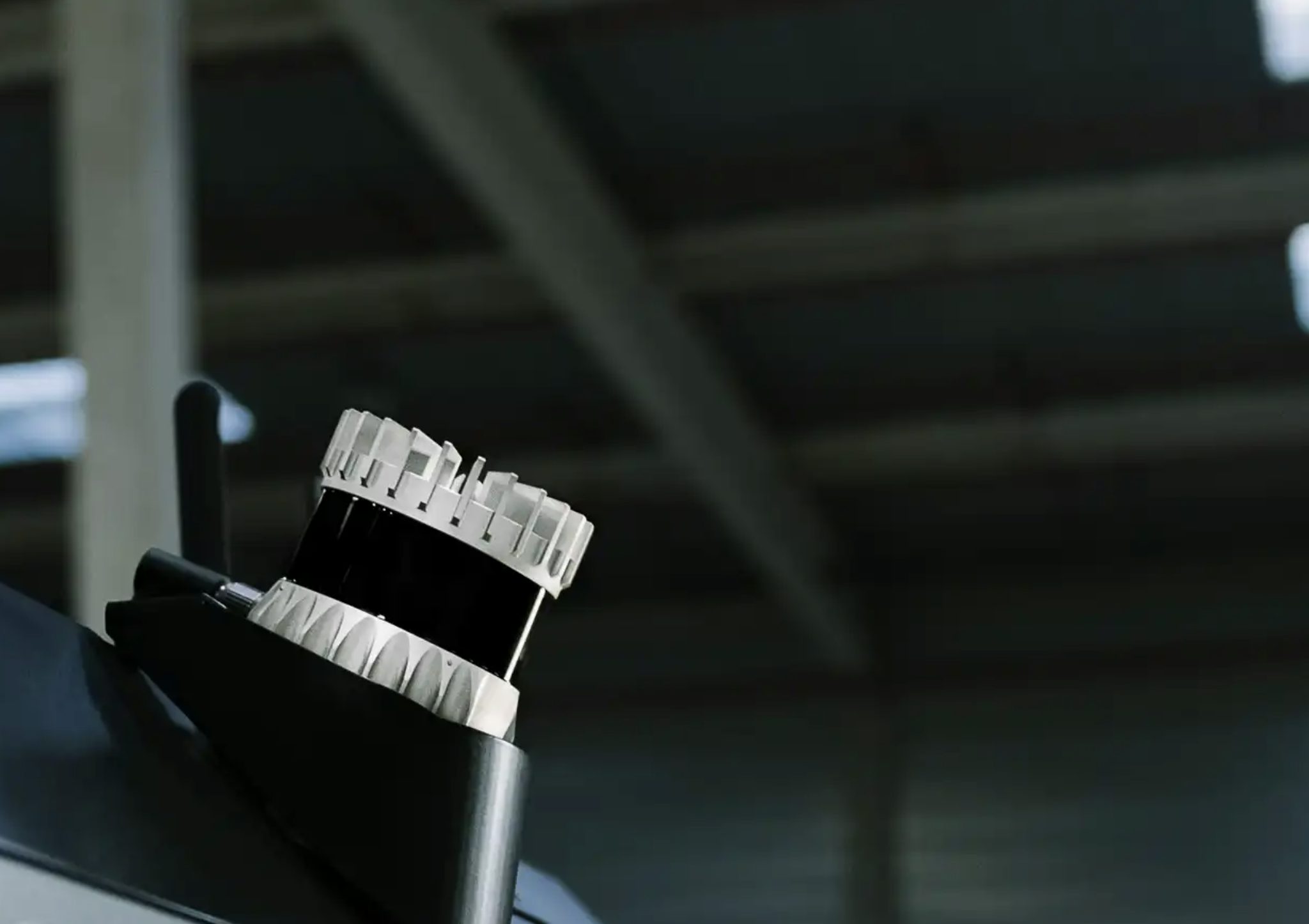
Beyond its 90 degree field-of-view, their team chose the Ouster OS0 for its durability, reliability, and incredibly rich, detailed, and precise data output. With help from their manufacturing partner, Deep Forestry has combined Ouster’s state-of-the-art lidars with their own unique twist of sensor fusion, autonomous robotics, and three dimensional deep learning algorithms. They’re now leveraging these forefront technologies in ways that realign the goals of industry and society, weaving them together towards the unifying goal of ensuring businesses and governments alike produce the maximum possible output, while simultaneously protecting and improving global forest ecosystems and the climate as a whole.
Stay in touch to get updates on companies like Deep Forestry as well as future case studies utilizing digital lidar to achieve the unthinkable.
Related Articles
Enhancing Warehouse Safety and Efficiency with Balyo and Ouster
Safety is the focal point of Balyo’s material handling automation business. Their latest platform helps warehousing and logistics companies enhance the safety of their operations and increase efficiency by increasing the object awareness of automated vehicles.
dConstruct and Ouster empower the autonomous robot navigation stack

Ouster REV8 OS1 Max debuts live at Automate 2026
Ouster brought Rev8 OS1 Max native color lidar to Automate 2026 in Chicago, marking the sensor's first live demo at a major robotics show since its May 4 launch. See how attendees, partners, and the industry reacted.