The Year of 3D Spatial AI Intelligence for Proactive Safety & Traffic Optimizations
Physical AI is driving traffic innovation in 2026. Learn about lidar-powered signal optimization, proactive safety analytics, and city-wide V2X integration.
The Intelligent Transportation Systems (ITS) industry is poised for further transformation in 2026. The conversation is shifting from experimental pilots to the scalable, operational reality of Physical AI. This appears to be the year when the convergence of advanced sensing, edge computing, and artificial intelligence moves past the theoretical to become a key component of our urban infrastructure and increasingly essential for tackling mobility challenges and maximizing road safety.
With respect to mobility in the United States, this shift is underscored by the latest INRIX 2025 Global Traffic Scorecard, which revealed that traffic congestion cost the U.S. over $85 billion last year, with the typical driver losing 49 hours to traffic. In cities like Chicago, that figure skyrocketed to 112 hours lost per driver. For road safety, the National Highway Traffic Safety Administration (NHTSA) reported a 3.8% decrease in U.S. traffic fatalities for 2024—the first time deaths have fallen below 40,000 since 2020—figures remain above pre-pandemic levels. For pedestrians, the Governors Highway Safety Association (GHSA) noted a 4.3% drop in deaths, although fatalities remain elevated compared to a decade ago, and reached a 40-year high in 2022.
The above statistics highlight both meaningful progress in the ITS industry and the critical need to further leverage higher-fidelity technologies to effectively address mobility and road safety challenges. In 2026, I see four deeply intertwined trends driving the current ITS transformation: the replacement of legacy detection, AI-powered signal optimization, the prioritization of proactive safety, and the integration of V2X networks.
1. The retirement of legacy detection in favor of AI-Powered traffic management
For decades, many critical traffic systems have relied on technologies like inductive loops, cameras and radar. While these tools offer basic traffic counting and presence detection, they are limited by data scarcity, vulnerability to environmental factors, and detection constraints. For example, inductive loops only detect a vehicle’s presence at a single point, offering limited insight into the complex, multimodal reality of today’s streets.
In 2026, I expect to see accelerated municipal programs dedicated to replacing this aging infrastructure. The mandate is clear: deploy solutions capable of generating rich, automated data. This systemic replacement is not merely a technology upgrade; it is a prerequisite for deploying effective AI models and achieving modern operational standards. For years, agencies have tested individual technologies—including lidar sensors—at one or two intersections within a municipality. In 2026, I expect to see these small-scale lidar pilots evolve into formalized, city-wide deployments. Progressive transportation leaders are now ready to commit to proven, scalable solutions. This transition requires robust procurement specifications, established data governance protocols, and confidence in a system's ability to seamlessly integrate with existing municipal infrastructure and budgets—moving technology from "pre-spec" testing environments into reliable, integrated systems.
Ouster is already seeing this transition in action; in the past year alone, we announced two of the largest lidar-enabled rollouts in the industry, covering 130+ intersections in Chattanooga and over 100 in Utah. These projects demonstrate that this technology is no longer just a "pilot"—it is ready for major infrastructure and safety programs.
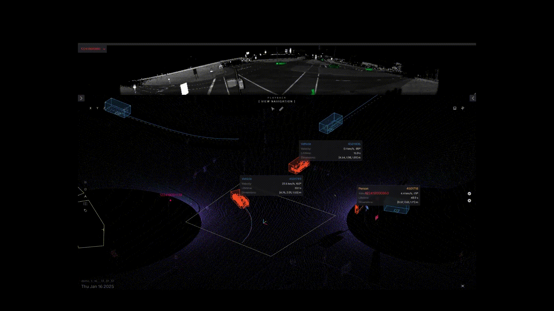
Lidar-powered Physical AI in action in Atlanta, Georgia
2. Adaptive traffic signal optimization using 3D spatial intelligence
As congestion costs in the U.S. surpass $85 billion annually, rigid, time-of-day signal programming is being retired in favor of Dynamic Actuation. In 2026, the future of the intersection hinges on automated, adaptive control systems driven by instantaneous 3D data. By utilizing continuous environmental streams from lidar, signals can now dynamically optimize timing based on real-time demand across all approach lanes.
For high-density cities like London and Chicago, this shift to adaptive intelligence is crucial for recouping lost economic value and slashing commuting times. These systems don't just "see" cars; they manage the entire multimodal flow, ensuring that a lone vehicle isn't idling at a red light while an empty cross-street holds the green. Lidar has emerged as a powerful ITS technology that is driving industry change. Lidar is non-invasive, low-maintenance, rugged, reliable in low-light and adverse weather conditions, and offers a modern approach to traffic management.
Ouster is at the forefront of lidar-based traffic signal actuation, with 400+ contracted deployments and unprecedented growth. We are proud to be the only digital lidar company that holds all three of the following certifications: (i) System-level NEMA TS2, (ii) digital lidar (OS1) NDAA, and (iii) Buy America(n)—all of which are crucial considerations for reliable and compliant U.S. traffic actuation.
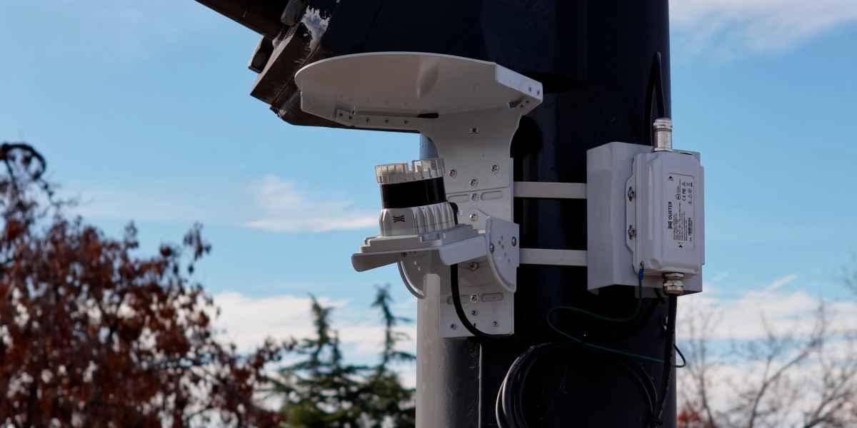
Ouster BlueCity installed at a Utah intersection
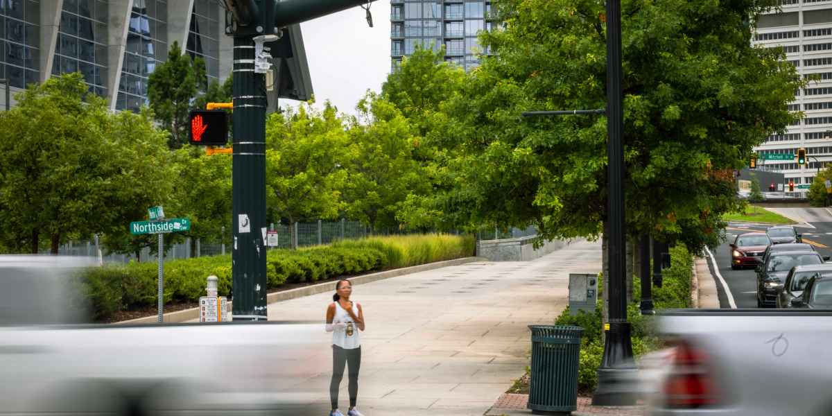
3. Siloed data to operational AI: Prioritizing VRU safety with automated high-fidelity data
The global push toward Vision Zero has made the protection of Vulnerable Road Users (VRUs)—pedestrians and cyclists—a top priority. Achieving this requires moving beyond sole reliance on historical crash reports to adopting a proactive safety analytics model. Next-generation ITS technology, often utilizing real-time 3D spatial awareness, is now capable of classifying and tracking road users with high accuracy and low latency. The goal is to establish a robust data foundation that reliably works 24/7, eliminating the need for manual, time-consuming, and inaccurate data collection. Agencies are increasingly recognizing that the cost of maintaining obsolete systems now outweighs the investment in future-proof, data-centric technology.Automated AI-powered data is transforming how agencies approach safety. This data allows transportation engineers to identify and analyze "near-miss" events, congestion bottlenecks, and unsafe behaviors (like jaywalking or red-light running) before a fatality occurs. Unlike collision data, which is reactive, near-miss data provides continuous, verifiable evidence that enables agencies to proactively and precisely target infrastructure investments—such as lengthening walk times or adjusting signal timing—moving from guesswork to granular, evidence-based intervention that enhances equity and accessibility for all road users.
An example automated near miss event recording from Ouster BlueCity analytics
4. The move towards V2X reality
One of the most transformative trends of 2026 is the bridge between comprehensive 3D data and Connected Transportation/Vehicle-to-Everything (V2X) communications. The focus has intensified on how roadside technology translates high-fidelity perception into standardized messages that vehicles can actually use. This complex processing is handled by Edge AI, which provides connected and automated vehicles with essential non-line-of-sight situational awareness. Ouster BlueCity plays a critical role for seamless V2X integration as discussed in detail in our V2X blog.
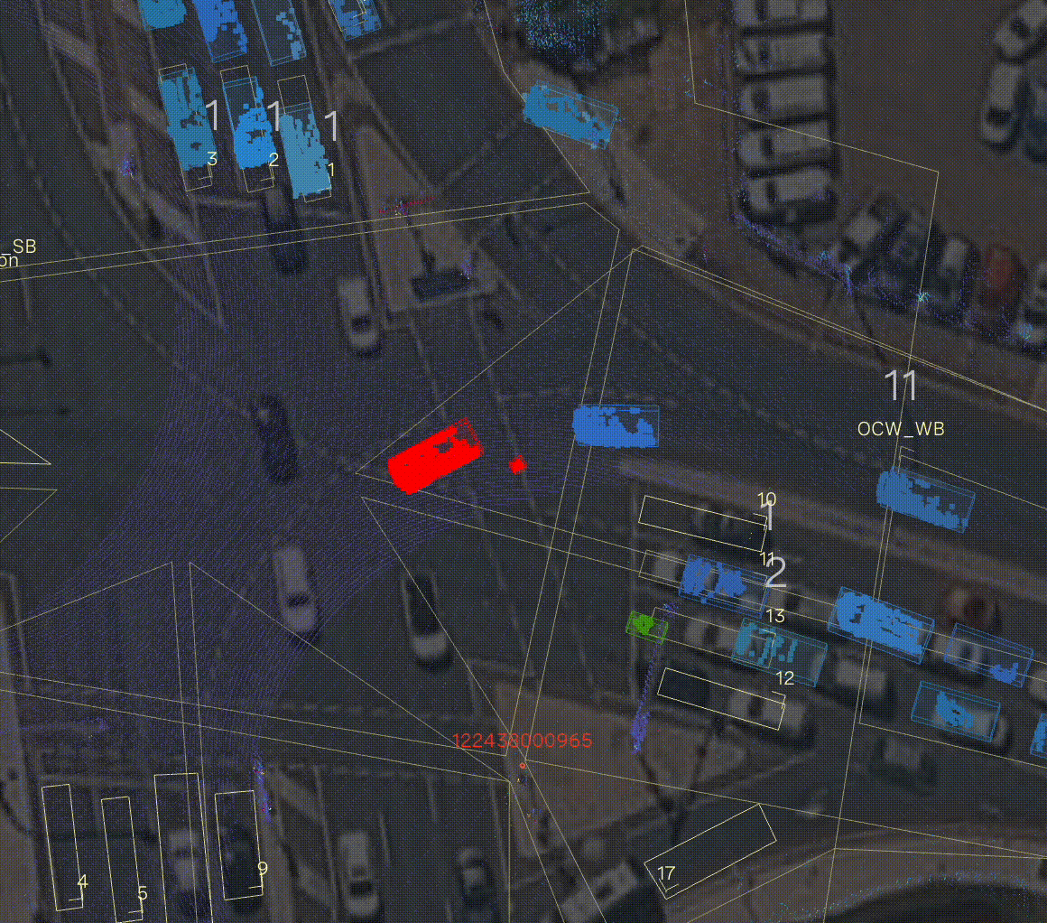
In collaboration with Ouster, agencies like Utah DOT and the City of Chattanooga are already leading the V2X charge. The Ouster BlueCity system captures the precise geolocation, speed, and trajectory of all road users in 3D and broadcasts to connected vehicles real-time SAE J2735 Basic Safety Messages (BSM) and Personal Safety Messages (PSM) via Roadside Units (RSUs). Furthermore, Ouster BlueCity supports the more advanced SAE J3224 (SDSM) standard, enabling the combination of information for all road users into a single, more comprehensive message that provides richer contextual awareness to connected vehicles. Ouster’s seamless V2X integration utilizes the same digital lidar system installation used for actuation and analytics to function as a safety communications hub, warning drivers of pedestrians or hazards before they even enter their field of vision.
Ouster BlueCity integrates into Road-Side Units for real-time V2X communications

Looking ahead with lidar-powered ITS
The path ahead for ITS is defined by intelligence, verifiable data, and tangible results for the public. By embracing these technologies, we empower agencies to manage traffic more efficiently to proactively protect our most vulnerable citizens, and ensure our digital infrastructure is robustly ready for the connected vehicle era. The rapid evolution of 3D spatial intelligence marks a turning point for transportation agencies worldwide. As the global lidar market is projected to reach over $12 billion by 2030, I believe we are moving into an era where high-resolution, long-range sensing is no longer a luxury, but the new standard for resilient urban design. By providing a "digital twin" of the roadway that remains accurate despite challenging weather and lighting conditions, digital lidar empowers agencies to move beyond fragmented, reactive fixes; instead, it offers a unified path toward Vision Zero by delivering the granular data necessary to protect vulnerable road users and the real-time responsiveness required to eliminate congestion through intelligent, adaptive signal control and improve road safety through next-generation analytics and alerts.
Looking toward the remainder of the decade, the integration of digital lidar with V2X communication will redefine the "Smart City" from a concept into a connected reality. Transportation leaders now have the tools to build a proactive infrastructure that not only sees the world in 3D but communicates those insights directly to vehicles and pedestrians to help prevent accidents before they occur. By investing in this high-fidelity data foundation today, agencies are doing more than just upgrading sensors; they are helping communities and businesses reclaim lost economic value and are ensuring that our future transportation networks are as safe, efficient, and equitable as the communities they serve.